

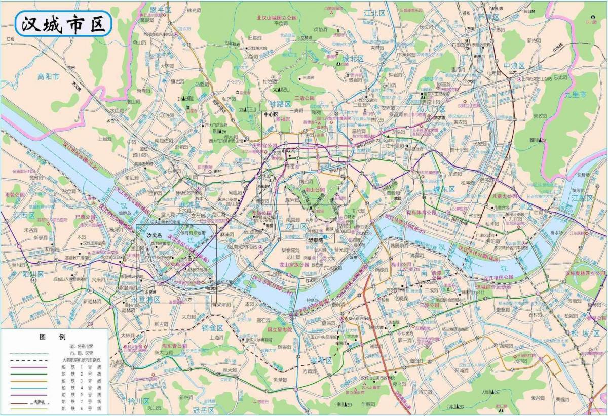
You can find on this page the Seoul streets map to print and to download in PDF. The Seoul roads map presents the road network, main roads, routes and motorways of Seoul in South Korea.

The Seoul streets map shows all street network and main roads of Seoul. This streets map of Seoul will allow you to find your routes through the streets of Seoul in South Korea. The Seoul streets map is downloadable in PDF, printable and free.
Gangnam is the center of Seoul. It is a street where various people gather from college students to workers, shopping shops and restaurants are gathered as its mentioned in Seoul streets map. Jamsil is more than a shopping street. Lotte Department Store, Lotte World Tower, and Lotte World Mall, which are made by “Lotte”, are a gathering place for various fashion brands, restaurants, home appliances stores and movie theaters.
The most historically significant street in Seoul is Jongno, meaning "Bell Street," on which one can find Bosingak, a pavilion containing a large bell as you can see in Seoul streets map. The bell signaled the different times of the day and therefore controlled the four major gates to the city of Seoul.
Myeongdong street not only consists of shopping, but it also includes commerce, culture, fashion, cosmetic shops, etc. This is the most famous shopping street in Seoul. Hongdae Street This young street consists of various activities like live music, delicious food, shopping facilities, etc. Garosu-Gil Street is very well known for the famous Korean artists whose studios used to be set up here (see Seoul streets map).

The Seoul roads map shows all road network and highways of Seoul. This roads map of Seoul will allow you to find your routes through the roads and motorways of Seoul in South Korea. The Seoul roads map is downloadable in PDF, printable and free.
The road networks of Seoul in the early Joseon Kingdom, when it was first selected as the national capital, were very well organized. Seoul at that time was a newly created capital city where roads and streets were square and straight with main roads being 17.5m wide, the medium roads 5m wide and small ones 3-4m wide. It was not until Japanese rule that modern road systems were first adopted in Seoul (see Seoul roads map).
The road ratio of Seoul soared from 8.7% in the 1960s to 22.32% in 2013, with the total road network expanding to over 8,197km over a surface area of 83.61km² (see Seoul roads map). Moreover, SMG upgraded the traffic signals at intersections, implemented reversible lanes along the arterial roads, and built the Seoul Traffic Control Center, all in an effort to upgrade the transport infrastructure of Seoul befitting its elevated status as a global city.
Major road networks in Seoul include 19 spur roads with a combined stretch of 236km as its shown in Seoul roads map, which go out in all directions from central districts to outer areas. Ring roads in Seoul disperse vehicles from the spur roads to several bypass ways which have a combined length of 111.4km.